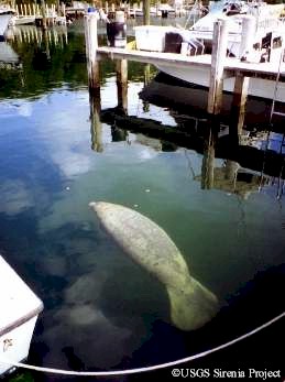
Figure 3 - Gina surface resting in the Great Harbour Cay marina. |
Florida Manatee Now
Residing In The Bahamas
By Jim Reid, US Geological
Survey/Sirenia Project
Although manatees have never been common in the Bahamas, sightings were on an increase throughout the 1990�s. A new star was added to the map in January 2000 when the Bahamas National Trust and Save the Manatee Club received reports of a manatee at Bullocks Harbor, Great Harbour Cay. When local residents first observed the manatee lounging in the marina on December 31, 1999, they considered it as a good omen for the coming millennium. I traveled to Great Harbour Cay in late February and found a small adult female (already nicknamed Gina) that appeared to be in good health and behaving normally. I was also able to gather information that revealed much about her interesting history.
Gina�s Resighting History
Proposed Travel Routes
This is a very
exciting discovery and relevant for explaining certain aspects of manatee
distribution. While Gina�s movements have been documented through
photo-identification records, radio tracking data from other manatees and
analyses of ocean currents allow us to propose a mechanism for how she arrived
in the Bahamas.
In April of 1998, a manatee raised in captivity was radio-tagged and released at Crystal River, FL. This individual, named Mo, soon wandered offshore and for three weeks no satellite-relayed locations were received. Finally, in late May, Mo�s transmitter indicated that he was about 120 miles off the southwest coast of Florida, in deep water, and well outside normal manatee habitat. Mo was rescued on June 3, twenty miles off the Dry Tortugas after drifting in offshore currents for 4 weeks.
Mo�s saga provides a scenario for how Gina arrived in the Bahamas. Manatees have been known to survive long periods without food or freshwater. It is likely that had Mo not been rescued, currents could have then taken him south of the Florida Keys and into the Gulf Stream. The opportunities for landfall are then to the west in Florida or east to the Great Bahama Bank. Gina could have had a similar offshore misadventure and come ashore in the Bahamas. Given the deep waters and strong currents separating Florida and the Bahamas, it is extremely unlikely that manatees purposely or repeatedly travel between them.
Gina�s
Future
Manatee distribution throughout the
species range is marked by close proximity to freshwater. Limited sources of
freshwater are believed to be the main factor restricting their numbers in the
Bahamas. Bullocks Harbor and the near-shore waters of Great Harbour Cay provide
appropriate habitats for manatee use. Given a reliable source of freshwater at
the marina, it is possible that Gina will thrive at this location. There is no
plan, or reason, for her to be returned to Florida. Provided that she remains
oriented to shallow waters, her future movements will likely be limited to other
sites on the Great Bahama Bank, especially those where freshwater is
available.
Thanks go to the
Bahamas� Department of Fisheries, the Bahamas National Trust, and Sapphire
Aviation. SMC member Leslie Kauseman and Save the Manatee Club staff assisted
with coordination. Thanks to the folks at AUTEC and Great Harbour Cay for the
care and consideration they have shown their resident manatee, Gina.
Update: June 2,
2000
I traveled to Great Harbour Cay from May 22-30,
2000. I was able to assess to condition of the resident manatee, Gina, and
attach a radio tag to her. A VHF transmitter/datalogging GPS receiver was
tethered for one week to determine local movement patterns. Feeding,
resting, and travel areas were documented through field observations. This
tag was replaced with a satellite-monitored transmitter on May 29, which she
continues to carry. Since early May, Gina has frequently been seen in the
company of another manatee, a shy small adult male. Gina and the male both
appear to be in good health. Recommendations to limit human contact,
establish sanctuary areas and limit boat speeds in the harbor will be made.
Jim Reid is a biologist with the
U.S. Geological Survey, Sirenia Project, a federal program initiated in the
mid-1970s to conduct detailed life history and ecological studies on
manatees.
Learn more about manatee research
by visiting the U.S.
Geological Survey, Sirenia Project Web site
Another Manatee Documented In The Bahamas
|
Figure 3 - Gina surface resting in the Great Harbour Cay marina. |
Great Harbour Cay Manatee Update,
July
2000
By Jim Reid, US Geological Survey/Sirenia
Project
After my February trip to check on Gina, residents
frequently saw her come and go from the marina basin. Except for a couple of
sightings in the harbor, no one was certain how far she ventured away from the
marina. In May 2000, I traveled
with veterinarian and USGS volunteer Dr. Peter Adams to Great Harbour Cay
(GHC) hoping to radio tag her for a brief period to determine some of her
movement patterns. The Bahamas Department of Fisheries, Sapphire Aviation, Save
the Manatee Club, GHC Marina, and support from local residents made this trip
possible.
The most significant finding from this trip was the documentation of another manatee at Great Harbor Cay! Starting in early May, Gina was frequently seen in the company of a shy, slightly smaller adult. This animal is a small adult male with an estimated total length of 265 to 270 cm. He can be identified by several gray propeller scars on his lower dorsal trunk, but otherwise is indistinct. The male has been given the photo-identification number BH-02. Gina and the male both appear to be in good health.
On
May 23, we radio tagged Gina by attaching the peduncle belt while snorkeling
with her in the marina basin. The floating tag was tethered to the belt using a
1.5-meter flexible nylon rod. The tag was a data-logging Global Positioning
System (GPS) receiver, coupled with a VHF transmitter used to locate the animal
in the field (Fig. 1, see below). This GPS receiver records many precise
locations enabling us to better determine details of her habitat use patterns,
while the VHF transmitter allows us to find her and observe her
behavior.
The GPS tag was programmed to attempt a location fix every 15 minutes. In order to obtain a location, it must remain at the surface for at least 20 seconds. When the manatee is swimming, the tag is mostly submerged and stays up for only a few seconds when the animal surfaces for air (Fig. 2, see below). As a result, most locations are obtained when the animal is sedentary near the surface or in shallow water, i.e. resting or feeding.
The tag attempted 574
GPS location fixes over the 143 hours that the tag was deployed; 287 (50 %) of
the attempts resulted in locations. A plot of all locations shows the greatest
use to be in the marina basin and in an undeveloped T-shaped canal (east side of
the harbor and north of the marina townhouses). She typically made a directed
move when traveling from the marina to the T-canal, spending little time
loitering in between. She did not make any trips outside of the harbor during
this period. The tag was removed on May 29, but the belt was left attached
around the base of the tail to help visually identify her.
Gina and the male were frequently seen together. As observed for Gina during the previous trip, the manatees were seen most frequently in the marina basin during the morning hours (Fig. 3, see at top). Typically between 0700h and 0900h, one or both would enter the marina by crossing the entrance channel and swimming under the docks to the end of the marina canal. Here they often spent hours resting under a mangrove tree. While Gina still occasionally took fresh water from garden hoses when offered by residents, the male was never seen doing this. They appeared to spend more time under some of the townhouses, sometimes drinking freshwater from the overflow of reverse osmosis systems that are operated for drinking water. Gina and the male typically left the marina in the late morning or early afternoon.
The primary feeding area
documented during this trip was in the southern portion of the T canal. Gina
and/or the male were seen here almost daily feeding on a small, but relatively
lush, Thalassia testudinum (turtle grass) seagrass bed. The southern
portion of Bullocks Harbor is protected from wave action and has ample seagrass
beds, although much of the area has waters less than 1m. Extensive
Thalassia meadows also occur outside the harbor cut. Overall, the type
and size of nearby habitats appear to be adequate for maintaining
manatees.
It is possible that the male and/or other manatees have
previously frequented Great Harbour Cay. Several residents recalled seeing an animal
resembling a manatee on several occasions during the past several years in the
T-canal to the north of the townhouses. Manatee sightings were not common
until Gina arrived at the first of this year. Now, even the male is conspicuous,
often leading Gina as they enter the marina. It is possible that he has learned
to enter and use resources in the marina that he had previously not utilized
because of his close association with the human-tolerant Gina. Gina and the male
are both mature, so it is possible that they could breed and Gina could give
birth to a calf next summer. Restrictions on human contact, limits on boat
speeds in the harbor, and establishment of sanctuary areas would be appropriate
actions to insure the manatees� safety.
Interestingly, residents have recently reported several
additional manatee sightings in the Berry Islands. On June 30 and July 1, Percy
Darville reported seeing a large manatee among the docks at Chub Cay (25 miles
south); marina personnel there reported that this was the first time a manatee
has been seen in the marina. During the week of July 9, a manatee sighting was
reported at Frozen (High) Cay and at Alder�s Cay. On July 14, a manatee was seen
at Little Whale Cay. These sightings, all reported from the southern Berry
Islands, were most likely of an additional manatee(s); reports suggest that Gina
and the male were frequently seen at GHC during this period. On July 16, local
resident Sue Kelly saw a manatee along the east shore of GHC swimming north just
offshore of the beach; this could have been the male circumnavigating
GHC.
Figure 1 - VHF/GPS tag prior to deployment. |
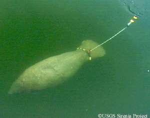
Figure 2 - Gina with VHF/GPS tag attached. |
Acknowledgment - Research was covered under permit
with the Ministry of Agriculture and Fisheries, Department of Fisheries; thanks
to Mr. Braynen (Director of Fisheries) and Mr. Vallierre Deleveaux. The tag
design is covered in USFWS permit number MA791721-2. Sapphire Aviation assisted
with transportation to and from Great Harbour. Thanks to Bob Larson for
accommodations and transportation on GHC, and to Beni and Sara with GHC Marina
for their support of manatee awareness campaigns. Save the Manatee Club provided
signs, educational material, and assisted with field expenses. Special thanks to
Audric, Bones, Caroline, Clarese, Claudette, Consuela, Edith, Elorn, Joey,
Monique, Mrs. Lewis, Mr. Finley, Mrs. T, Nathan, Norma, Patricia, Paul and
Janet, Percy, Rochelle, Rudie, Rufus, Ruth, Shirley, Shoes, Smitty, Sue, Tommy,
Willa-May, and the rest of the folks of Great Harbour Cay for the care and
consideration they have shown their resident manatees.
Jim Reid is a biologist with the
U.S. Geological Survey, Sirenia Project, a federal program initiated in the
mid-1970s to conduct detailed life history and ecological studies on
manatees.
Learn more about manatee research
by visiting the U.S.
Geological Survey, Sirenia Project Web
site